Mestá a obce disponujú množstvom údajov a technológií pre ich zber. Často im však chýba prepojenie a kontext, ktorý by umožnil efektívne využitie týchto dát pre rozvoj územia. Projekt EnCLOD prichádza s riešením v podobe mikrozonácie – konceptu, ktorý prináša poriadok do spleti mestských dát.
Čo je mikrozonácia a prečo je dôležitá?
Mikrozonácia je inovatívny prístup k zberu a spracovaniu dát pre územné plánovanie, ktorý vyvinul projekt EnCLOD. Jeho podstatou je rozdelenie územia na menšie, logické celky – mikrozóny. Vďaka tomu je možné efektívne prepájať rôznorodé údaje a odpovedať na kľúčové otázky.
Mikrozóny slúžia ako základ pre komplexné plánovanie rozmiestnenia senzorov internetu vecí (IoT) a ďalší zber dát. Umožňujú charakterizovať a porovnávať jednotlivé zóny medzi sebou a agregovať údaje, najmä tie citlivé, ako napríklad spotreba vody či energie. Vďaka tomu získavajú mestá cenné informácie pre plánovanie investícií a rozvoj ekologických riešení.
Princípy návrhu mikrozón
Pri tvorbe mikrozón je dôležité dodržiavať niekoľko kľúčových pravidiel:
- Rešpektovanie urbanistických a štatistických jednotiek: Mikrozóny musia rešpektovať existujúce urbanistické a štatistické jednotky sčítania, aby nedochádzalo k ich prekrývaniu.
- Logika kreovania mikrozón: Hranice mikrozón by mali vychádzať z prirodzených hraníc, ako sú rieky, železnice, hlavné cesty či hranice susedných obcí, mobility a funkčného využitia mikrozóny,
- Komplexné umiestnenie senzorov: Senzory IoT by mali byť navrhnuté tak, aby boli reprezentatívne pre konkrétnu riešenú agendu a zabezpečili komplexné monitorovanie územia (napr. z hľadiska dopravného môžu byť senzory umiestnené na vstupe a výstupe zón, aby zabezpečili presné monitorovanie dopravy, príp. ak je účelom bezpečnosť dopravy, môžu byť nasadené vybraných kritických miestch – typicky prechodoch pre chodcov).
- Holistický prístup: Vychádza z komplexného návrhu zberu dát a identifikácii existujúcich technológií relevantných pre riešenú agendu a územie so zameraním sa na sprístupnenie týchto dát a vypracovanie stratégie ich nasadenia, spravovania vrátane financovania a využitia pre praktickú politiku samosprávy.
Mikrozonácia v praxi: Príklad Žiliny
Mesto Žilina, ako administratívne, hospodárske a kultúrne centrum severozápadného Slovenska, čelí výzvam spojeným s dopravou a územným rozvojom. V rámci projektu EnCLOD bola Žilina rozdelená do približne 60 mikrozón, ktoré rešpektujú prirodzené hranice, a štatistické jednotky a funkčné využitie územia. Toto rozdelenie umožňuje systematický zber dát o doprave, klíme a ďalších faktoroch, ktoré sú dôležité pre plánovanie a rozvoj mesta.
Mapovanie zdrojov dát
Dôležitou súčasťou projektu EnCLOD je mapovanie existujúcich zdrojov dát v meste, ako sú dopravné senzory, sčítače dopravy a meteorologické stanice. Cieľom je zmapovať pokrytie týmito technológiami a identifikovať miesta, kde je potrebné doplniť senzory pre komplexné pokrytie územia.
Existujúce technológie v Žiline
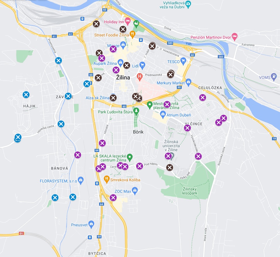
V Žiline už existuje viacero technológií, ktoré zbierajú cenné dáta pre potreby mesta. Nasadzovaním senzorov v Žiline sa kontinuálne buduje Živé mestské laboratórium, ktoré sa začalo budovať projektom Clevernet a naďalej sa rozširuje vďaka projektom NXTLVL Parking a EnCLOD . V Žiline sa tak podarilo vybudovať komplexnú sieť dopravných senzorov, ktoré sú zobrazené na nasledujúcom obrázku.

Traffic sensor network in Žilina (X CLEVERNET + X NXTLVL Parking + X EnCLOD)
The traffic sensors monitor vehicle passages, their category and speed.
Other sources of traffic data include:
1. Traffic counters: traffic counters are placed at the main entrances to Žilina to monitor traffic volume and provide information on the number, speed and category of vehicles.
2. Speed cameras: speed cameras (radars) are placed in the city to not only check compliance with regulations, but also to collect data on the intensity and speed of vehicles.
3. Bicycle counters: To promote green transport, bicycle counters are placed at selected locations to record the number, speed and direction of cyclists.
Microzonation is an important step towards efficient and meaningful data collection for urban planning purposes. It enables cities to better understand their needs and make informed decisions about their development.
The EnCLOD project in Žilina is an example of how microzonation can be successfully implemented and the benefits it brings to a city and its inhabitants.